
Freunden von diesem Artikel berichten:
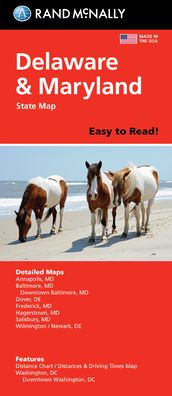
Rand McNally Easy to Read: Delaware, Maryland State Map
Rand Mcnally

Rand McNally Easy to Read: Delaware, Maryland State Map
Rand Mcnally
Rand McNally's folded map for Delaware and Maryland is a must-have for anyone traveling in or through these states, offering unbeatable accuracy and reliability at a great price. Our trusted cartography shows all Interstate, U. S., state, and county highways and much more. - Points of interest. - State Park chart. - State mileage chart. - Driving times map. - On-the-road toolbox. - Visitor center information. - Climate data. - State facts & symbols. - Easy-to-use legend. Coverage Area Detailed maps include: Dover, DE; Wilmington, DE; Annapolis, MD; Baltimore, MD; Baltimore Downtown, MD; Frederick, MD; Hagerstown, MD; Washington, D. C., Washington, D. C. Downtown. Product Details: Measures 9.0 x 4.125 and folds out to 25.5 x 36.75.
show more
| Medien | Bücher Taschenbuch (Buch mit Softcover und geklebtem Rücken) |
| Erscheinungsdatum | 16. Mai 2022 |
| ISBN13 | 9780528025686 |
| Verlag | RAND MCNALLY |
| Maße | 250 g (Geschätztes Gewicht) |
| Sprache | Englisch |
Weitere Titel von Rand Mcnally


Andere haben auch gekauft
![Cover for Preben Hansen · Turen Går Til: Turen går til Californien & Vestlige USA (Taschenbuch) [5. Ausgabe] (2021)](https://imusic.b-cdn.net/images/item/original/578/9788740063578.jpg?preben-hansen-2021-turen-gaar-til-turen-gaar-til-californien-vestlige-usa-taschenbuch&class=scaled&v=1623395637)
![Cover for Ole Lund Kirkegaard · Læs selv: Læs selv Frode - og alle de andre rødder (Gebundesens Buch) [4. Ausgabe] [Indbundet] (2010)](https://imusic.b-cdn.net/images/item/original/121/9788702094121.jpg?ole-lund-kirkegaard-2010-laes-selv-laes-selv-frode-og-alle-de-andre-roedder-gebundesens-buch&class=scaled&v=1331420409)
![Cover for Yahya Hassan · Yahya Hassan 2 (Taschenbuch) [1. Ausgabe] (2019)](https://imusic.b-cdn.net/images/item/original/866/9788702265866.jpg?yahya-hassan-2019-yahya-hassan-2-taschenbuch&class=scaled&v=1573199860)
![Cover for Peter Ingemann · Den Gyldne Hest (Gebundesens Buch) [1. Ausgabe] (2021)](https://imusic.b-cdn.net/images/item/original/526/9788702330526.jpg?peter-ingemann-2021-den-gyldne-hest-gebundesens-buch&class=scaled&v=1633520816)


Alle Titel von Rand Mcnally ansehen ( u. a. Taschenbuch , Landkarten , Gebundenes Buch , Buch und Spiralbuch )