
Freunden von diesem Artikel berichten:
John Muir Trail (topographic Map Guide): National Geographic California 2022nd edition
National Geographic Maps
Bestellware

John Muir Trail (topographic Map Guide): National Geographic California 2022nd edition
National Geographic Maps
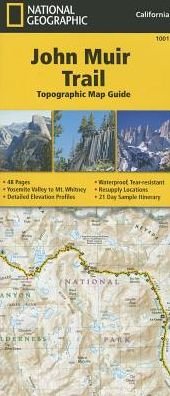
Publisher Marketing: -Waterproof -Tear-Resistant -Topographic Map GuideNational Geographic's Map Guide of the John Muir Trail is an indispensable tool for navigating one of the most famous trails in the United States. Expertly researched and created in partnership with local land management agencies, this product provides detailed topographic maps, interesting history, a waypoint table, information about resupply and bear safety, and key points of interest you will encounter along the trail. Formatted to meet your needs while navigating this breathtaking and remote trail, the maps within the guide are one-inch-equals-one-mile (1:63,360) making it easy to calculate distances. Each map page has a trail profile that shows the elevation changes you will encounter. Also, the John Muir Trail is highlighted and centered on each page so you can easily track your progress. The maps start at the northern terminus in Yosemite Valley and progress along the ridge of the Sierra Nevada, past Devils Postpile, and end at the highest point in the lower 48 on the top of Mount Whitney. Along the way you will pass through; Yosemite National Park, Ansel Adams Wilderness, Devils Postpile National Monument, John Muir Wilderness, Kings Canyon National Park, and finally, Sequoia National Park and Mount Whitney. All proceeds from the purchase of National Geographic maps help support the Society's vital exploration, conservation, scientific research, and education programs. Download the GPX file of landmarks along the John Muir Trail. These landmarks match the "Landmarks and Waypoints" page in the John Muir Trail Topographic Map Guide. JohnMuirTrail.gpx"Map Scale = 1:63,360Sheet Size = 8.5" x 9.25"Folded Size = 4.25" x 9.25"" Contributor Bio: National Geographic Maps - Trails Illustrated Founded in 1915 as the Cartographic Group, the first division of the National Geographic Society, National Geographic Maps has been responsible for illustrating the world around us through the art and science of mapmaking. Today, National Geographic Maps continues this mission by creating the world's best wall maps, recreation maps, atlases, and globes which inspire people to care about and explore their world. All proceeds from the sale of National Geographic maps go to support the Society's non-profit mission to increase global understanding and promote conservation of our planet through exploration, research, and education.
| Medien | Bücher Landkarten (Land- oder Seekarten) |
| Erscheinungsdatum | 26. September 2014 |
| ISBN13 | 9781566956895 |
| Verlag | National Geographic Maps |
| Seitenanzahl | 1 |
| Maße | 239 × 107 × 7 mm · 86 g |
| Sprache | Englisch |
Weitere Titel von National Geographic Maps
![Cover for National Geographic Maps · Road Atlas - Adventure Edition (Landkarten) [2024th Adventure edition] (2024)](https://imusic.b-cdn.net/images/item/original/890/9780792289890.jpg?national-geographic-maps-2024-road-atlas-adventure-edition-landkarten&class=scaled&v=1433670741)
![Cover for National Geographic Maps · National Forests and Grasslands of the United States Map - National Geographic Destination Map (Landkarten) [2023rd edition] (2024)](https://imusic.b-cdn.net/images/item/original/407/9781566959407.jpg?national-geographic-maps-2024-national-forests-and-grasslands-of-the-united-states-map-national-geographic-destination-map-landkarten&class=scaled&v=1713230308)
![Cover for National Geographic Maps · Acadia National Day Hikes and National Park [Map Pack Bundle] - National Geographic Trails Illustrated Map (Landkarten) [2023rd edition] (2024)](https://imusic.b-cdn.net/images/item/original/162/9781566959162.jpg?national-geographic-maps-2024-acadia-national-day-hikes-and-national-park-map-pack-bundle-national-geographic-trails-illustrated-map-landkarten&class=scaled&v=1713230308)

![Cover for National Geographic Maps · National Parks & National Forest of the Us [Map Pack Bundle] - National Geographic Destination Map (Landkarten) [2023rd edition] (2024)](https://imusic.b-cdn.net/images/item/original/452/9781566959452.jpg?national-geographic-maps-2024-national-parks-national-forest-of-the-us-map-pack-bundle-national-geographic-destination-map-landkarten&class=scaled&v=1713230308)

![Cover for National Geographic Maps · Camino de Santiago - Camino France Map 3 of 4: Terradillos de los Templarios to Ponferrada - National Geographic Trails Illustrated Map (Landkarten) [2024th edition] (2024)](https://imusic.b-cdn.net/images/item/original/216/9781566959216.jpg?national-geographic-maps-2024-camino-de-santiago-camino-france-map-3-of-4-terradillos-de-los-templarios-to-ponferrada-national-geographic-trails-illustrated-map-landkarten&class=scaled&v=1713230308)


![Cover for National Geographic Maps · National Geographic Night Sky - Southern Hemisphere Map (Stargazer Folded) - National Geographic Reference Map (Landkarten) [2024th edition] (2024)](https://imusic.b-cdn.net/images/item/original/513/9781566959513.jpg?national-geographic-maps-2024-national-geographic-night-sky-southern-hemisphere-map-stargazer-folded-national-geographic-reference-map-landkarten&class=scaled&v=1713230308)
![Cover for National Geographic Maps · National Geographic Solar System Map (Stargazer Folded) - National Geographic Reference Map (Landkarten) [2024th edition] (2024)](https://imusic.b-cdn.net/images/item/original/520/9781566959520.jpg?national-geographic-maps-2024-national-geographic-solar-system-map-stargazer-folded-national-geographic-reference-map-landkarten&class=scaled&v=1713230308)


![Cover for National Geographic Maps · National Geographic Africa Map (Folded with Flags and Facts) - National Geographic Reference Map (Landkarten) [2022nd edition] (2024)](https://imusic.b-cdn.net/images/item/original/292/9781566959292.jpg?national-geographic-maps-2024-national-geographic-africa-map-folded-with-flags-and-facts-national-geographic-reference-map-landkarten&class=scaled&v=1713230295)
![Cover for National Geographic Maps · National Geographic Europe Map (Folded with Flags and Facts) - National Geographic Reference Map (Landkarten) [2022nd edition] (2024)](https://imusic.b-cdn.net/images/item/original/322/9781566959322.jpg?national-geographic-maps-2024-national-geographic-europe-map-folded-with-flags-and-facts-national-geographic-reference-map-landkarten&class=scaled&v=1713230295)
![Cover for National Geographic Maps · National Geographic North America Map (Folded with Flags and Facts) - National Geographic Reference Map (Landkarten) [2022nd edition] (2024)](https://imusic.b-cdn.net/images/item/original/339/9781566959339.jpg?national-geographic-maps-2024-national-geographic-north-america-map-folded-with-flags-and-facts-national-geographic-reference-map-landkarten&class=scaled&v=1713230295)
![Cover for National Geographic Maps · National Geographic Space (Stargazer Folded Map Pack Bundle) - National Geographic Reference Map (Landkarten) [2024th edition] (2024)](https://imusic.b-cdn.net/images/item/original/599/9781566959599.jpg?national-geographic-maps-2024-national-geographic-space-stargazer-folded-map-pack-bundle-national-geographic-reference-map-landkarten&class=scaled&v=1713230308)
![Cover for National Geographic Maps · National Geographic South America and Antarctica Map (Folded with Flags and Facts) - National Geographic Reference Map (Landkarten) [2022nd edition] (2024)](https://imusic.b-cdn.net/images/item/original/346/9781566959346.jpg?national-geographic-maps-2024-national-geographic-south-america-and-antarctica-map-folded-with-flags-and-facts-national-geographic-reference-map-landkarten&class=scaled&v=1713230295)
![Cover for National Geographic Maps · National Geographic Night Sky (Stargazer Folded Map Pack Bundle) - National Geographic Reference Map (Landkarten) [2024th edition] (2024)](https://imusic.b-cdn.net/images/item/original/605/9781566959605.jpg?national-geographic-maps-2024-national-geographic-night-sky-stargazer-folded-map-pack-bundle-national-geographic-reference-map-landkarten&class=scaled&v=1713230308)
![Cover for National Geographic Maps · Buenos Aires: City Destintation Map and Travel Guide (Landkarten) [2018th edition] (2024)](https://imusic.b-cdn.net/images/item/original/724/9781566957724.jpg?national-geographic-maps-2024-buenos-aires-city-destintation-map-and-travel-guide-landkarten&class=scaled&v=1614662555)

![Cover for National Geographic Maps · Colorado (Landkarten) [2022nd edition] (2024)](https://imusic.b-cdn.net/images/item/original/779/9781566957779.jpg?national-geographic-maps-2024-colorado-landkarten&class=scaled&v=1614699234)
![Cover for National Geographic Maps · Florence: City Destination Map and Travel Guide (Landkarten) [2023rd edition] (2023)](https://imusic.b-cdn.net/images/item/original/311/9781566957311.jpg?national-geographic-maps-2023-florence-city-destination-map-and-travel-guide-landkarten&class=scaled&v=1603937082)
![Cover for National Geographic Maps · North Carolina (Landkarten) [2023rd edition] (2023)](https://imusic.b-cdn.net/images/item/original/762/9781566957762.jpg?national-geographic-maps-2023-north-carolina-landkarten&class=scaled&v=1650633122)
![Cover for National Geographic Maps · Tennessee (Landkarten) [2023rd edition] (2023)](https://imusic.b-cdn.net/images/item/original/274/9781566957274.jpg?national-geographic-maps-2023-tennessee-landkarten&class=scaled&v=1699506776)
![Cover for National Geographic Maps · National Geographic Australia and Oceania Map (Folded with Flags and Facts) - National Geographic Reference Map (Landkarten) [2022nd edition] (2023)](https://imusic.b-cdn.net/images/item/original/315/9781566959315.jpg?national-geographic-maps-2023-national-geographic-australia-and-oceania-map-folded-with-flags-and-facts-national-geographic-reference-map-landkarten&class=scaled&v=1713230296)
![Cover for National Geographic Maps · Acadia National Park Day Hikes Map - National Geographic Topographic Map Guide (Landkarten) [2023rd edition] (2023)](https://imusic.b-cdn.net/images/item/original/100/9781566959100.jpg?national-geographic-maps-2023-acadia-national-park-day-hikes-map-national-geographic-topographic-map-guide-landkarten&class=scaled&v=1697947311)
![Cover for National Geographic Maps · World For Kids, The, Poster Sized, Laminated: Wall Maps World (Landkarten) [2019th edition] (2023)](https://imusic.b-cdn.net/images/item/original/962/9781597755962.jpg?national-geographic-maps-2023-world-for-kids-the-poster-sized-laminated-wall-maps-world-landkarten&class=scaled&v=1447624459)
![Cover for National Geographic Maps · Grand Canyon National Park Day Hikes Map - National Geographic Topographic Map Guide (Landkarten) [2023rd edition] (2023)](https://imusic.b-cdn.net/images/item/original/070/9781566959070.jpg?national-geographic-maps-2023-grand-canyon-national-park-day-hikes-map-national-geographic-topographic-map-guide-landkarten&class=scaled&v=1697947311)
![Cover for National Geographic Maps · Death Valley National Park Day Hikes Map - National Geographic Topographic Map Guide (Landkarten) [2023rd edition] (2023)](https://imusic.b-cdn.net/images/item/original/974/9781566958974.jpg?national-geographic-maps-2023-death-valley-national-park-day-hikes-map-national-geographic-topographic-map-guide-landkarten&class=scaled&v=1697947311)
Andere haben auch gekauft

Alle Titel von National Geographic Maps ansehen ( u. a. Landkarten , Taschenbuch , Buch und Lose Papiere )