

Freunden von diesem Artikel berichten:
Rand McNally Folded Map: Western United States
Rand McNally

Rand McNally Folded Map: Western United States
Rand McNally
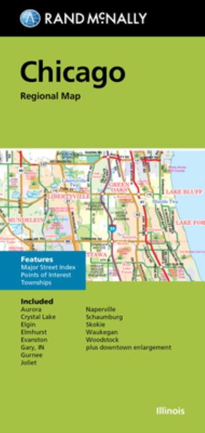
Rand McNally's folded map featuring the Western United States is a must-have for anyone traveling in and around this part of the country, offering unbeatable accuracy and reliability at a great price. Our trusted cartography shows all Interstate, state, and county highways, along with clearly indicated points of interest, airports, county boundaries, and more. You'll see why Rand McNally folded maps have been the trusted standard for years. -Regularly updated, full-color maps. -Clearly labeled Interstate, U. S., state, and county highways. -Detail maps of major cities, a mileage chart, and a Mileages & Driving Times Map. -Indications of parks, points of interest, airports, county boundaries, and more. -Easy-to-use legend. -Detailed index. -Convenient folded size. Coverage Area: Arizona, California, Colorado, Idaho, Montana, Nevada, New Mexico, Oregon, Utah, Washington, Wyoming. Product Details: Measures 9.5 x 4.125 and folds out to 40 x 28. Scale: 1 = 43 miles.
| Medien | Bücher Landkarten (Land- oder Seekarten) |
| Erscheinungsdatum | 6. August 2021 |
| ISBN13 | 9780528025174 |
| Verlag | Rand McNally |
| Maße | 102 × 236 × 8 mm · 250 g (Geschätztes Gewicht) |
| Sprache | Englisch |
Weitere Titel von Rand McNally


![Cover for Rand McNally · A Pocket Atlas of the [world] [cartographic Material]: Presented to the Patrons and Friends of the Chicago & North-Western Ry. Co. With the Compliments of the Passenger Department (Taschenbuch) (2021)](https://imusic.b-cdn.net/images/item/original/417/9781015179417.jpg?rand-mcnally-2021-a-pocket-atlas-of-the-world-cartographic-material-presented-to-the-patrons-and-friends-of-the-chicago-north-western-ry-co-with-the-compliments-of-the-passenger-department-taschenbuch&class=scaled&v=1649334010)


Andere haben auch gekauft
![Cover for Preben Hansen · Turen Går Til: Turen går til Californien & Vestlige USA (Taschenbuch) [5. Ausgabe] (2021)](https://imusic.b-cdn.net/images/item/original/578/9788740063578.jpg?preben-hansen-2021-turen-gaar-til-turen-gaar-til-californien-vestlige-usa-taschenbuch&class=scaled&v=1623395637)
![Cover for J. K. Rowling · Harry Potter: Harry Potter 6 - Harry Potter og Halvblodsprinsen (Gebundesens Buch) [5. Ausgabe] (2015)](https://imusic.b-cdn.net/images/item/original/277/9788702173277.jpg?j-k-rowling-2015-harry-potter-harry-potter-6-harry-potter-og-halvblodsprinsen-gebundesens-buch&class=scaled&v=1441302687)
![Cover for Olga Ravn · De ansatte (Taschenbuch) [1. Ausgabe] (2018)](https://imusic.b-cdn.net/images/item/original/583/9788702265583.jpg?olga-ravn-2018-de-ansatte-taschenbuch&class=scaled&v=1521711504)
![Cover for Paludans Bilatlas over Europa 2016 (Spiralbuch) [1. Ausgabe] (2016)](https://imusic.b-cdn.net/images/item/original/473/9788772307473.jpg?2016-paludans-bilatlas-over-europa-2016-spiralbuch&class=scaled&v=1532297840)
![Cover for Betty Edwards · Drawing on the Right Side of the Brain: A Course in Enhancing Creativity and Artistic Confidence: definitive 4th edition (Gebundenes Buch) [Main edition] (2013)](https://imusic.b-cdn.net/images/item/original/778/9780285641778.jpg?betty-edwards-2013-drawing-on-the-right-side-of-the-brain-a-course-in-enhancing-creativity-and-artistic-confidence-definitive-4th-edition-gebundenes-buch&class=scaled&v=1398870041)

![Cover for Kent Haruf · Eventide - Plainsong (Taschenbuch) [Main Market Ed. edition] (2013)](https://imusic.b-cdn.net/images/item/original/457/9781447240457.jpg?kent-haruf-2013-eventide-plainsong-taschenbuch&class=scaled&v=1396360108)


![Cover for Barbara Kingsolver · Demon Copperhead: Winner of the Women's Prize for Fiction (Taschenbuch) [Main - Re-issue edition] (2023)](https://imusic.b-cdn.net/images/item/original/483/9780571376483.jpg?barbara-kingsolver-2023-demon-copperhead-winner-of-the-women-s-prize-for-fiction-taschenbuch&class=scaled&v=1680172538)
![Cover for Disney · Carl Barks & Don Rosa Bind II (Gebundenes Buch) [1. Ausgabe] (2020)](https://imusic.b-cdn.net/images/item/original/218/9788793840218.jpg?disney-2020-carl-barks-don-rosa-bind-ii-gebundenes-buch&class=scaled&v=1596799987)
Alle Titel von Rand McNally ansehen ( u. a. Taschenbuch , Landkarten , Gebundenes Buch , Buch und Spiralbuch )