
Freunden von diesem Artikel berichten:
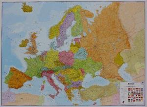
Europe - Europa political wall map laminated
Maps International

Europe - Europa political wall map laminated
Maps International
Laminated flat map of Europe in the scale 1:4.3 mill. Size: Width 165 cm x hight 120 cm. Our politically coloured wall map of Europe features countries marked in different colours, with international boundaries shown. All major towns and cities of Europe are featured within our map, and the countries capital cities are clearly marked. The map contains hill and sea shading adding to the vibrant overall effect. The wall map also contains a section showing the different flags of countries in Europe. This Large Europe Wall Map Political (Laminated) with encapsulation gives the map a write on / wipe off finish. Using a dry wipe marker, any writing on the map can be wiped off with a proprietary cleaner.
| Medien | Bücher Landkarten (Land- oder Seekarten) |
| Erscheinungsdatum | 1. März 2019 |
| ISBN13 | 9781903030660 |
| Verlag | Maps International |
| Genre | Maps & Guides |
| Maße | 150 × 210 × 22 mm · 381 g |
| Sprache | Englisch |
Weitere Titel von Maps International
![Cover for Maps International · World political laminated (Landkarten) [Revised edition] (2020)](https://imusic.b-cdn.net/images/item/original/578/9781903030578.jpg?maps-international-2020-world-political-laminated-landkarten&class=scaled&v=1479800114)

Andere haben auch gekauft
![Cover for John le Carré · Spioners arv (Gebundesens Buch) [1. Ausgabe] (2017)](https://imusic.b-cdn.net/images/item/original/323/9788763853323.jpg?john-le-carre-2017-spioners-arv-gebundesens-buch&class=scaled&v=1500638106)
![Cover for Lasse Holm · Romeren (Taschenbuch) [1. Ausgabe] (2016)](https://imusic.b-cdn.net/images/item/original/262/9788771760262.jpg?lasse-holm-2016-romeren-taschenbuch&class=scaled&v=1457794445)
![Cover for Lasse Holm · Republikaneren (Gebundesens Buch) [1. Ausgabe] (2016)](https://imusic.b-cdn.net/images/item/original/286/9788771760286.jpg?lasse-holm-2016-republikaneren-gebundesens-buch&class=scaled&v=1454168947)
![Cover for Lasse Holm · Grækeren (Gebundesens Buch) [1. Ausgabe] (2015)](https://imusic.b-cdn.net/images/item/original/889/9788792320889.jpg?lasse-holm-2015-graekeren-gebundesens-buch&class=scaled&v=1426967051)
Alle Titel von Maps International ansehen ( u. a. Landkarten und Buch )